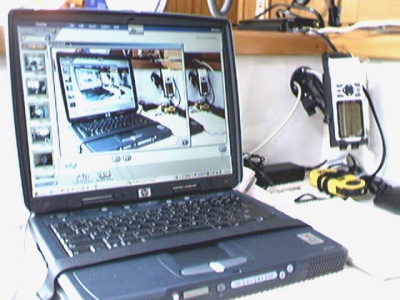
Nav Station PC Set-up
By Mike Roy, Cat's Paw #1373
I'm using "The Cap'n" navigation software (excellent program) on a Hewlett Packard laptop with a 15" screen. Garmin 48 GPS data is fed into the computer. GPS is mounted near but out of the way of the chart table and its lid, and hardwired for power. GPS is always "on". Remote GPS antenna is mounted on the pushpit between the port pushpit seat and the ladder. When computer is off, it is either stowed in its case or covered with a towel to minimize exposure to water vapor.
Processed data from computer is primarily viewed on computer screen and also routed to the Raytheon ST50 instruments at the helm. Because of instruments' "Seatalk" capability, numerical data (heading, speed, steering info) can be viewed on radar display and autopilot display.
Note velcro tie-down for computer. Computer also sits on shock absorbing non-skid mat. Computer is powered via inverter using standard AC power source. (Will get special DC to AC converter for this computer (about $100) rather than use inverter; I'm told that's much more efficient.)
Note mounting bracket for GPS. Holes in its base were large enough to allow routing GPS power cable and external antenna cable, thereby hiding those holes in the bulkhead behind the base. Makes for a neater installation.
Although the layout looks intuitive I put a lot of thought into it and possible interferences. This "aid to navigation" and its layout works very well.
Mark Tamblyn, Alena #326
I am using an E Book Windows PC with USB gps and SeaClear software. When setting up SeaClear to work with the NOAA RNC charts be sure to place the charts in the location SeaClear is expecting them BEFORE you load the SeaClear software. The location is C:\Program Files\SeaClear\charts If you do this then SeaClear will index all the charts and find the correct chart for your location. NOAA RNC download charts at http://www.charts.noaa.gov/InteractiveCatalog/ncgd.shtml
